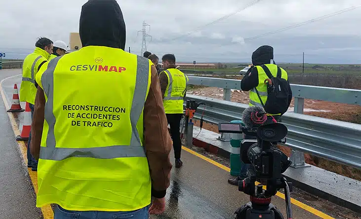
After a traffic accident, investigators meticulously collect data to develop a detailed analysis of the incident. The adoption of new technologies, such as drones and photogrammetry systems, makes it possible to obtain detailed images and videos of the accident scene. These resources, along with witness testimonies and reports from authorities, form a solid foundation for the accurate reconstruction of events, allowing investigators to identify causes and assign responsibilities effectively.
The importance of accurate accident reconstruction
Accurate reconstruction of the causes of traffic accidents is crucial not only to clarify how and why the events occurred, but also to improve advanced driver assistance systems (ADAS) and other aspects of vehicles, where possible. Insurance companies also depend on this information to determine liability and manage compensation fairly and efficiently. Technological advancement, through the use of techniques such as photogrammetry and LiDAR technology—point cloud data of the terrain captured through an airborne laser scanner—has transformed this field. It is now possible to create “digital twins”, which are accurate three-dimensional models of the accident scene for study or review during accident reconstruction.
These advanced tools provide a detailed and reliable representation of the site and lead to a more comprehensive analysis. This not only facilitates accurate assignment of responsibility and damage assessment, but also contributes significantly to the prevention of future accidents by providing key data that can be used to improve road safety.
[dica_carousel_plxs_map urls=”https://www.mapfre.com/media/2025/10/45-km-1-300×169-1.webp,https://www.mapfre.com/media/2025/10/45-km-2-300×169-1.webp,https://www.mapfre.com/media/2025/10/45-km-3-300×168-1.webp,https://www.mapfre.com/media/2025/10/45-km-4-300×169-1.webp,https://www.mapfre.com/media/2025/10/45-km-5-300×169-1.webp”]
State-of-the-art technology for reliable reconstruction
Technological innovations are revolutionizing the way we analyze traffic accidents by enabling experts to collect more detailed and reliable information and perform real-time data dumping. This not only speeds up the reconstruction of the accident, but also saves time and increases productivity by streamlining the work of the person leading the investigation.
The integration of new technologies with aerial images obtained through drones provides an essential complementary perspective for a holistic understanding of events, significantly enhancing accuracy and reliability in determining causes and responsibilities. This convergence optimizes investigation processes and aids in crafting more efficient strategies to prevent future accidents, representing a noteworthy progression in road safety.
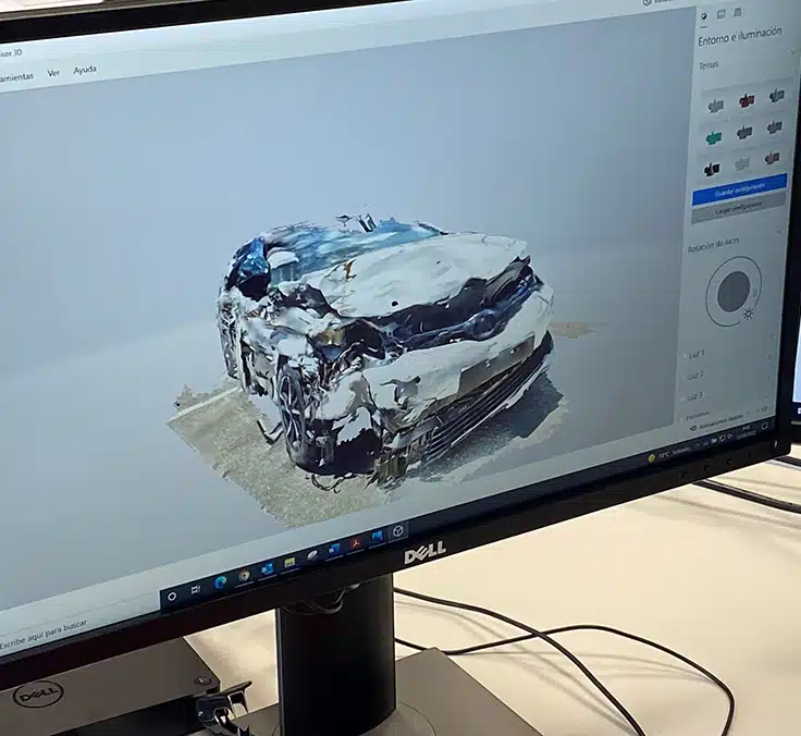
3D scanning used in traffic accident investigation involves the comprehensive capture of the spatial geometry of the accident site, resulting in precise 3D digital twins. This methodology captures critical details such as vehicle position, track markings, and other key elements, providing a solid basis for detailed analysis and accurate reconstruction of events, which are essential for identifying causes and assigning responsibility with greater accuracy.
Photogrammetry in accident investigation, on the other hand, focuses on accurately defining the shape, dimensions, and spatial position of the objects involved using photographs of the scene. Similar to 3D scanning, this method reconstructs 3D models from images by transforming point clouds into 3D meshes. Only a few photographs are required to generate these detailed models, making it easier to perform a thorough and accurate analysis of the accident scene.
The application of Geographic Information Systems (GIS) in traffic accident reconstruction also has wide-ranging benefits. Thanks to geographic data, digital twins can be developed to incorporate real-time information on the incident, displaying the road network and its elements and facilitating previews, measurements, etc.
In conclusion, adopting cutting-edge technologies has transformed the accident reconstruction process by making it not only faster but also significantly more precise.
CESVIMAP, Mapfre’s R&D center, remains at the forefront of the traffic accident studies, incorporating advanced solutions that streamline detailed analysis in less time. This enables it to propose improvements in traffic accident analysis that enhance road safety. CESVIMAP also suggests innovations in the design of certain parts to vehicle manufacturers. By joining forces with manufacturers and research centers and making recommendations on certain traffic policies, the number of accidents can be reduced.